


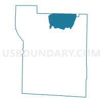
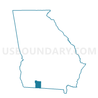
275104 - COOLIDGE Voting District, Thomas County, Georgia
About
Outline

Summary
| Unique Area Identifier | 562938 |
| Name | 275104 - COOLIDGE Voting District |
| County | Thomas County |
| State | Georgia |
| Area (square miles) | 34.88 |
| Land Area (square miles) | 34.45 |
| Water Area (square miles) | 0.43 |
| % of Land Area | 98.78 |
| % of Water Area | 1.22 |
| Latitude of the Internal Point | 31.00636820 |
| Longtitude of the Internal Point | -83.86981490 |
Maps

Graphs
Select a template below for downloading or customizing gragh for 275104 - COOLIDGE Voting District, Thomas County, Georgia


Neighbors
Neighoring Voting District (by Name) Neighboring Voting District on the Map
- 0710007 - AUTREYVILLE Voting District, Colquitt County, GA
- 0710008 - BRIDGECREEK Voting District, Colquitt County, GA
- 0710018 - MURPHY Voting District, Colquitt County, GA
- 275106 - ELLABELLE Voting District, Thomas County, GA
- 275112 - MERRILLVILLE Voting District, Thomas County, GA
- 275116 - PATTEN Voting District, Thomas County, GA
- 275117 - PAVO Voting District, Thomas County, GA
Top 10 Neighboring County Subdivision (by Population) Neighboring County Subdivision on the Map
- Moultrie CCD, Colquitt County, GA (27,838)
- Funston CCD, Colquitt County, GA (6,280)
- Ochlocknee CCD, Thomas County, GA (4,010)
- Pavo-Barwick CCD, Thomas County, GA (2,410)
- Coolidge CCD, Thomas County, GA (2,295)
Top 10 Neighboring Place (by Population) Neighboring Place on the Map
Top 10 Neighboring Unified School District (by Population) Neighboring Unified School District on the Map
Top 10 Neighboring State Legislative District Lower Chamber (by Population) Neighboring State Legislative District Lower Chamber on the Map
- State House District 170, GA (51,371)
- State House District 173, GA (48,578)
- State House District 171, GA (45,696)
Top 10 Neighboring State Legislative District Upper Chamber (by Population) Neighboring State Legislative District Upper Chamber on the Map
Top 10 Neighboring 111th Congressional District (by Population) Neighboring 111th Congressional District on the Map
Top 10 Neighboring Census Tract (by Population) Neighboring Census Tract on the Map
- Census Tract 9706, Colquitt County, GA (6,643)
- Census Tract 9709, Colquitt County, GA (6,280)
- Census Tract 9602, Thomas County, GA (4,010)
- Census Tract 9604, Thomas County, GA (2,410)
- Census Tract 9603, Thomas County, GA (2,295)